Location
The Deer Creek Watershed drains approximately 37 square miles (23,500 acres) of St. Louis County. Originating in the northwest in Creve Coeur near Highway 270 and Olive, Deer Creek flows in a southeasterly direction approximately 10.76 miles before it enters the River des Peres at Maplewood, near Highway 44 and McCausland. Several maps outlining watershed characteristics are below. Click here to see additional watershed maps.

Deer Creek Watershed Location. | Source: University of Missouri Center for Applied Research and Environmental Systems (CARES)
Municipalities
The Deer Creek Watershed encompasses all or part of 21 municipalities including:
- Brentwood
- Clayton
- Country Life Acres
- Creve Coeur
- Crystal Lake Park
- Des Peres
- Frontenac
- Glendale
- Huntleigh
- Kirkwood
- Ladue
- Maplewood
- Olivette
- Richmond Heights
- Rock Hill
- Shrewsbury
- Town and County
- University City
- Warson Woods
- Webster Groves
- Westwood

Sub-watersheds
Deer Creek Watershed is a sub-watershed of the larger River des Peres watershed, which is included in the St. Louis Tributaries (HUC Number 07140101 and referred to as #21 in map at right) to the Mississippi River.

Regional Watershed Boundaries | Source: East-West Gateway Council of Governments | Download pdf [1.18 MB]
Deer Creek Watershed has itself been divided into four sub-watersheds for analysis and association of issues and concerns. Drainage patterns with resulting stream flow to common points were used for the demarcation between sub-watersheds. The four sub-watersheds are:
- Upper Deer Creek
- Twomile Creek
- Lower Deer Creek
- Black Creek

Deer Creek Sub-watersheds map | Source: East-West Gateway Council of Governments
Streams
The major contributing streams within the Deer Creek Watershed are Deer Creek (stream order 4), Twomile Creek (stream order 3), Sebago Creek (stream order 2), Shady Grove Creek (stream order 2), and Black Creek (stream order 3). For several miles above Two-Mile Creek, Deer Creek is a third order stream. In a 1993 report from the Litzsinger Ecology Center (LREC), which is located five miles upstream from the confluence with River Des Peres, Deer Creek is described as perennial stream although in “mid-summer when precipitation is least and evapo-transpiration is highest” it may experience only intermittent pools. (Dr. Clifford Ochs, An Ecological Survey of the Litzsinger Road Ecology Center [2.39MB], 1992).
Karst Topology & Geology
Karst topology is characterized by the presence of caves, springs, sink holes and losing streams and is created as groundwater dissolves soluble rock such as limestone or dolomite. Limestone is a sedimentary rock composed of calcium carbonate. The rock is of marine origin and derived from the lime mud and ooze that accumulated on calm, shallow sea floors. Approximately 166 sinks holes, which are rounded depressions in the landscape formed when an underground cavity collapses, have been identified in the watershed. A majority of the sink holes are concentrated in the central area of the watershed between Ladue Road, Brentwood Boulevard, and Rock Hill Road. The sinkholes tend to follow the creek drainages.

Deer Creek Watershed Karst and Sinkholes | Source: East-West Gateway Council of Governments
Land Cover
Land cover in the Deer Creek Watershed is 82.21% urban with just 8.42% forest, 8.38% grassland, 0.47% crop land, 0.40% water, and 0.12% wetland. The 2005 Land Cover map below characterizes the upper watershed as primarily low density residential, and the lower watershed as primarily high density residential.
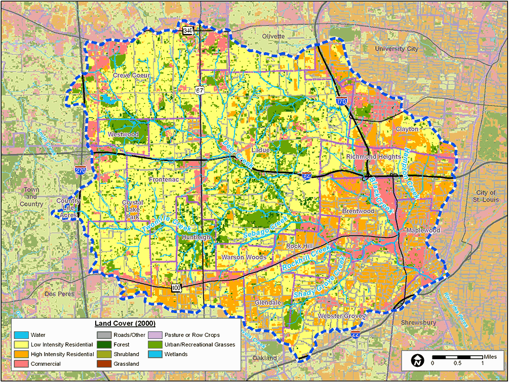
Deer Creek Watershed Land Cover | Source: University of Missouri Center for Applied Research and Environmental Systems (CARES)
Land Use
Land use in the Deer Creek Watershed in 2008 is reflected in the map below. The watershed is 71% residential, primarily made up of single-family homes. In addition, 11% of the watershed is allocated for park, recreational or agricultural open space; 9% of the watershed is used for commercial/industrial purposes, 8% of the land is owned by institutions, and there is no data for 1% of the land area.

Deer Creek Watershed Land Use | Source: East-West Gateway Council of Governments